BeiDou Intelligent Application Technology Training Platform
Product Features
BeiDou-3 Core Module Integration
Equipped with a BeiDou-3 high-precision differential positioning module, the platform supports RTK differential correction data from ground-based augmentation networks as well as satellite-based PPP-RTK positioning. It integrates RNSS positioning, orientation, Bluetooth communication, radio communication, and Wi-Fi, enabling centimeter-level high-precision positioning.
Multi-Mode Integrated Positioning
Supports BeiDou/GPS dual-mode combined positioning as well as standalone positioning. The platform provides standard NMEA-0183 data output, supports positioning data output testing and protocol parsing, and is compatible with mainstream industry data formats.
Full-Stack Teaching and Research Platform
The BeiDou Spatiotemporal Intelligent Host Development Kit integrates navigation and positioning, communication, and remote sensing functions into a single platform. Running on Windows 10 with a graphical user interface, it supports multiple programming languages, including Python, C, and Java, and allows additional software packages to be installed. It supports a progressive learning pathway from introductory technology education and classroom learning to industry-oriented applications.
Modular Hardware Architecture
The receiver consists of six independent modules and supports module-level inspection, troubleshooting, and maintenance training. The accompanying soldering kit uses large-package components to facilitate hands-on soldering and assembly practice.
· RF module
· Baseband module
· Positioning solution module
· Power module
· Clock module
· Interface module
BeiDou Short Message Satellite Communication
Equipped with a BeiDou-3 short message communication module and BeiDou card, the platform supports satellite communication and active positioning through PC-based host software. It can also be integrated with microcontrollers and sensors to build IoT systems, extending its use to applications such as emergency communications and field monitoring.
Expandable IoT Ecosystem
The Navigation & Communication IoT Kit includes a microcontroller development board and more than 20 sensor modules. It supports embedded software development and enables students to build complete IoT applications.
· Field disaster early-warning systems
· Vehicle tracking and monitoring systems
· Unattended weather stations
· Other BeiDou-enabled IoT applications
Project-Based Engineering Training
The platform is supplied with a complete curriculum and practical training manuals. Using emerging industries such as “BeiDou + Low-Altitude Economy” as representative application areas, the training covers the complete project workflow from system design and hardware/software development to integration, commissioning, and testing.
IP67-Rated Industrial Protection
The BeiDou High-Precision Enhanced Development Kit features IP67-rated protection and a ruggedized design for continuous operation. It is equipped with a high-brightness 2K HD display, enabling stable operation in complex outdoor environments and supporting field-based practical training.
Specifications
Software Configuration
|
Category |
Configuration |
Version / Requirement |
|
Operating System |
Windows 64-bit |
Windows 10 or later |
|
Development Environment |
Python / C / Java |
Multi-language support; additional software packages can be installed |
|
Positioning Protocol |
NMEA-0183 |
Standard output format with protocol parsing support |
|
Data Services |
CORS RTK / PPP-RTK |
Ground-based and satellite-based augmentation positioning |
Hardware Configuration
BeiDou High-Precision Enhanced Development Kit
|
Item |
Specification |
|
Positioning Module |
BeiDou-3 high-precision differential positioning module |
|
Positioning Mode |
BeiDou/GPS dual-mode combined positioning; standalone positioning supported |
|
Differential Positioning |
Ground-based RTK augmentation / satellite-based PPP-RTK augmentation |
|
Communication |
Bluetooth, radio, Wi-Fi |
|
Protection Rating |
IP67 ruggedized protection |
|
Display |
High-brightness 2K HD display |
|
Operating Capability |
Supports continuous operation |
|
Cloud Platform Connectivity |
Supports data upload to the proprietary cloud platform, coordinate reference system transformation, trajectory storage, and high-precision map creation |
BeiDou Spatiotemporal Intelligent Host Development Kit
|
Item |
Specification |
|
Core Functions |
Integrated BeiDou navigation & positioning, communication, and remote sensing |
|
Operating System |
Windows 10 with graphical user interface |
|
Programming Languages |
Python, C, Java; additional software packages supported |
|
Hardware Control |
Microcontroller control; serial and USB interfaces for connecting various sensors |
|
Applications |
Teaching and research for emerging spatiotemporal technology applications |
Practical Training Kit Configuration
|
Kit |
Type |
Core Functions |
|
BeiDou High-Precision Enhanced Development Kit |
Required |
RTK differential positioning, PPP-RTK, cloud data services, high-precision mapping |
|
BeiDou Spatiotemporal Intelligent Host Development Kit |
Required |
Multi-language development, sensor control, intelligent system development |
|
Receiver Soldering Training Kit |
Required |
BeiDou receiver soldering and assembly, NMEA-0183 output testing, dual-mode positioning |
|
Inspection & Maintenance Training Kit |
Required |
Independent inspection of six receiver modules; fault diagnosis using multimeters, oscilloscopes, and spectrum analyzers |
|
Satellite Communication Training Kit |
Optional |
BeiDou-3 short message communication, active positioning, and IoT networking |
|
Navigation & Communication IoT Kit |
Optional |
Microcontroller development, 20+ sensor modules, and IoT system development |
Recommended Operating Environment
|
Equipment |
Recommended Specification |
|
Processor |
Intel Core i5 or above |
|
Memory |
8 GB DDR4 or above |
|
Storage |
256 GB SSD or above |
|
Monitor |
23-inch, 1920 × 1080 resolution |
|
Power Supply |
Single-phase 220 V / 1.5 kW dedicated workstation power supply with grounding protection |
Application Scenarios
Scenario 1: BeiDou Receiver Assembly and Commissioning Training
Designed for students in secondary and higher vocational education, this training scenario covers the complete practical workflow of a BeiDou receiver, from PCB soldering and board-level commissioning to complete system functional verification.
Students assemble and solder components according to the Bill of Materials (BOM), conduct electrical safety inspections using multimeters and oscilloscopes, and use PC-based host software to monitor satellite signal reception and positioning data in real time, including:
· Latitude and longitude
· Altitude
· Number of satellites
Students also verify compliance with the NMEA-0183 data format. Through the training process, students develop practical capabilities in:
· Electronic soldering and assembly
· Test instrument operation
· Fault diagnosis and troubleshooting
· Engineering documentation
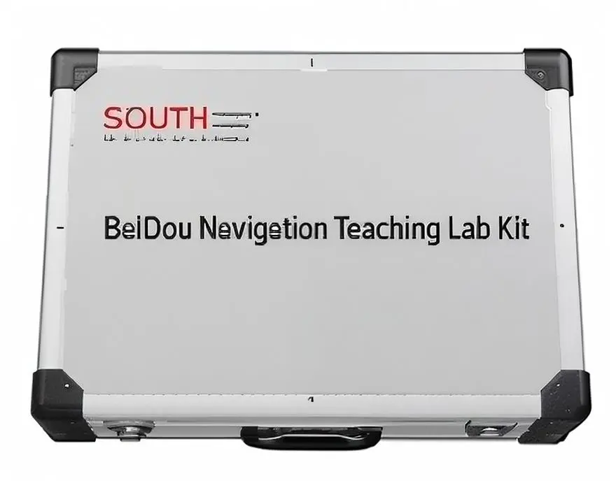

Figure 1. BeiDou Navigation Teaching Lab Kit
Scenario 2: “BeiDou + Low-Altitude Economy” Application Development
Designed for university student teams, this scenario focuses on typical low-altitude applications such as:
· Low-altitude logistics and delivery
· Regional inspection
Based on the BeiDou Spatiotemporal Intelligent Host Development Kit, students build hardware systems and develop core functional modules. By integrating geographic information technology, artificial intelligence, and the Internet of Things, students complete:
· Multi-sensor data fusion
· High-precision positioning and communication
· Business process integration
Students are expected to complete a functional system prototype within 90 minutes, followed by 60 minutes of integrated testing and validation, and submit a design report including:
· System block diagram
· Core program code
· Test results
This application scenario directly supports skills development for emerging industries such as low-altitude logistics and urban air mobility.
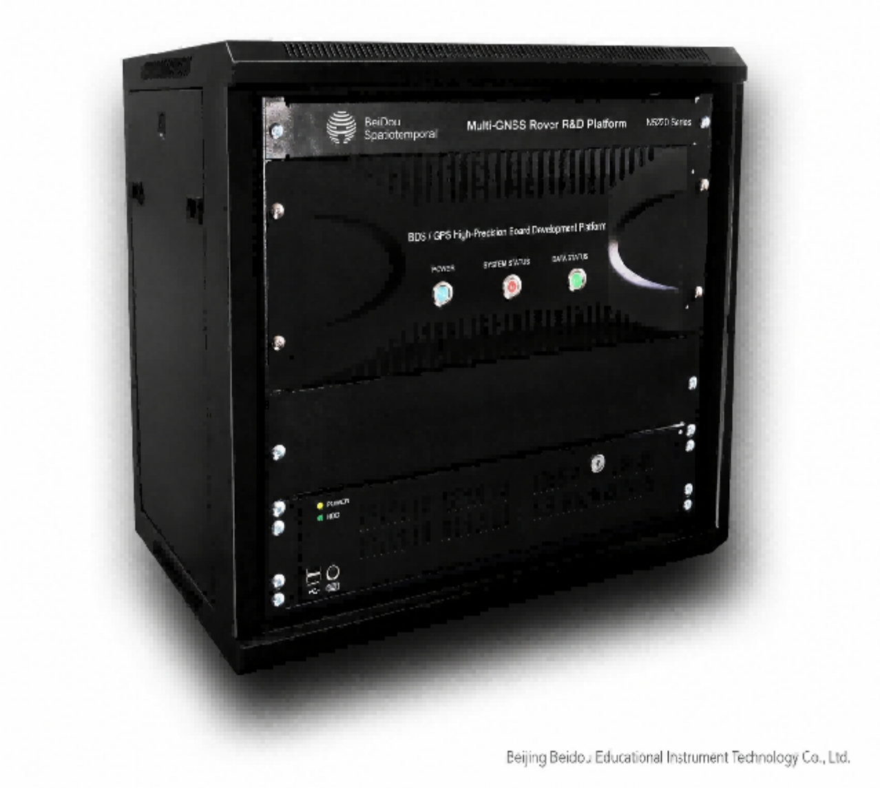
Figure 2. BeiDou Multi-Mode Satellite Navigation Receiver R&D Platform
Scenario 3: BeiDou + IoT Innovative Applications
Using the microcontroller development board and more than 20 sensor modules included in the Navigation & Communication IoT Kit, together with BeiDou-3 short message communication technology, students can develop complete IoT projects such as:
· Field disaster early-warning systems
· Vehicle tracking and monitoring systems
· Smart night-light systems
· Unattended weather stations
Through embedded programming, students control sensor data acquisition and use the BeiDou short message communication module for satellite communication and active positioning in areas without terrestrial public network coverage. This scenario develops practical capabilities in:
· Embedded system development
· System integration
· Engineering innovation
The Inspection & Maintenance Training Kit also supports fault diagnosis training for the receiver’s six independent modules:
· RF
· Baseband
· Positioning solution
· Power
· Clock
· Interface
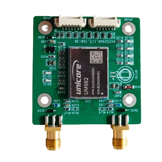
Figure 3. BeiDou High-Precision Positioning Module Circuit Board
Scenario 4: Teaching Innovation and Research
Designed for teachers and instructors, the platform supports both innovative teaching design and technical prototype development. It can be used to develop:
· New course syllabi
· Interdisciplinary course modules
· Virtual simulation experiments
· Comprehensive laboratory projects
· Technical prototypes
· Teaching and research projects
Teachers can also use the platform to conduct educational and technical research, prepare research papers, and conduct project presentations and defenses. By integrating advanced BeiDou technologies with emerging developments in the low-altitude economy, the platform helps transform industry technologies into high-quality teaching resources and research topics, supporting “BeiDou+” curriculum reform and interdisciplinary collaboration.
Scenario 5: High-Precision Surveying and Outdoor Field Training
The BeiDou High-Precision Enhanced Development Kit connects to the BeiDou ground-based augmentation system (CORS) through a dedicated application to obtain RTK correction services, enabling centimeter-level positioning accuracy. Through cloud platform connectivity, users can perform:
· Positioning data uploading and analysis
· Coordinate reference system transformation
· Positioning trajectory storage and retrieval
· High-precision map creation
With its IP67-rated protection, the system supports continuous outdoor operation and can be used for:
· Surveying training
· Geographic information data collection
· Engineering setting-out
FAQ
Q: Which programs and education levels is the BeiDou Intelligent Application Technology Training Platform suitable for?
A: The platform adopts a system-level architecture and supports a progressive learning pathway from introductory technology education and practical training to industry-oriented applications. It can meet the teaching and training needs of:
· Secondary vocational schools
· Higher vocational colleges
· Application-oriented universities
· Teachers and instructors
For secondary vocational education, the focus can be placed on receiver soldering, assembly, and basic operation. For higher education, the platform supports more advanced applications such as “BeiDou + Low-Altitude Economy” system development and system integration. For teachers, the platform can be used for innovative teaching design and research project development.
Q: Does the platform support multiple programming languages?
A: Yes. The BeiDou Spatiotemporal Intelligent Host Development Kit runs on Windows 10 and provides a graphical user interface. It supports multiple programming languages, including:
· Python
· C
· Java
Additional software packages can also be installed. The system also provides microcontroller control capabilities. Through software programming, users can control serial and USB interfaces and connect various sensors.
Q: How does the platform achieve high-precision positioning?
A: The platform includes a BeiDou High-Precision Enhanced Development Kit featuring a BeiDou-3 high-precision differential positioning module. It supports:
· Ground-based RTK differential correction
· Satellite-based PPP-RTK positioning
Through a dedicated application connected to the BeiDou Continuously Operating Reference Station (CORS) network, the system can obtain RTK positioning services and achieve centimeter-level positioning accuracy.
_1781601799781.webp)